


Weather Network: Summer will linger into fall


- Details
- Published on Wednesday, 25 May 2016 18:54
- Written by The Peorian

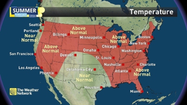
The Weather Network's team of meteorologists has released their Summer Forecast for the months of June, July and August, giving a look at what's to come forthe United States. Many indications point to a warmer and drier season for the central and eastern parts of the country compared to the past three years.
Overall, early indications are that summer will linger well into the fall months for an extended summer season. While most of the country can expect warmer temperatures to dominate, these conditions are not expected to be extreme. Hot and dry conditions are projected to dominate in the Midwest, with the northern half of the country expected to experience shifting weather patterns for the first part of the season as summer fights to take hold. Meanwhile, the southern and central Plains will have a wet start to the season and finish near to above normal.
"Sea surface temperatures affect weather patterns globally in significant ways. El Niño, which has been a major influence in weather patterns globally for the past several seasons is transitioning quickly to La Niña. La Niña conditions won't be confirmed officially until early fall and while no two La Niña's are ever the same, models are giving indications that this could be a strong one," saidChris Scott, Chief Meteorologist with The Weather Network. "Typically for the US, these conditions bring warmer and drier conditions to the south and cooler and wetter conditions in the Pacific Northwest. Every year is unique though, and warmer than normal water off both the east and west coasts will alter the typical La Niña pattern."
The Atlantic hurricane season begins officially onJune 1st, and this year, there are indications for a more active season than in previous years. A normal season has 11 named storms, with six reaching hurricane status and two being considered a category three or above with winds of at least 111 miles per hour. Warmer than normal sea surface temperatures in theGulf of Mexicoand off the coast of the eastern US will elevate the potential for storms to maintain or increase in strength near the coast of the US.
Complete Summer Forecast details, including regional breakdowns, maps and charts are availablehere. Americans can access detailed weather information whenever they need it atwww.theweathernetwork.com/usor by downloading The Weather Network app fromGoogle PlayoriTunes.